Saturday, October 8, 2016

Hurricane Matthew Blog - Part 5, Post-Florida Observations

The hurricane has gone from Florida.  But it might not be the last of Hurricane Matthew in the Bahamas, Cuba, and Florida.

Granted, many things can happen in just five days, as evinced by the entire track history of just about every hurricane.  Should it live so long, it might actually make a loop-d-loop.  Many storms have done this, but fortunately Matthew won't be able to strengthen much as it will be re-entering waters that are chilled from the passage of Matthew.  It isn't, however, the only storm to drive up the coast like that.  The other two named hurricanes that did, 1979 David and 1964 Cleo, are both retired; the third was unnamed in 1926.
Notice that all 3 of these storms were (a) a major hurricane at one point, (b) were Category 2 or weaker when they impacted the coast, and (c) made landfall.  Clearly, even Brevard County has the potential for impacts from major hurricanes even if the circumstances favorable for such an event aren't likely to come together that often.

There are several factors that help determine the effects of a storm, but here's just some of the possibilities: the lunar cycle, the tides, wind speed, distance from the eye, the velocity, and the size of the wind field.

The wobbles created by the eyewall replacement cycle spared the east coast of Florida from what would have been the largest natural disaster since Hurricane Katrina, likely surpassing it.  The east coast is highly populated, and Category 3-4 winds would have been wreaking havoc from Grant-Valkaria up to Jacksonville, with Category 1 winds or so in the adjacent inland counties, such as Orange and Seminole Counties.

Check out the storm track history here: Matthew track

At one point, the forecast was for the eye of the storm to rip right up Brevard County at 145 mph winds.  This was why people were encouraged to leave, especially on the beach.  At that point, the coast was looking at storm surge of around 11-15 feet, with many beaches being under this at their peak altitude, meaning the barrier island as a whole would have been swamped.  Even Jim Cantore said that he thought the county as a whole was unsafe and went all the way down to Fort Pierce.

Still a monster, but a more distant one
The eyewall replacement was a saving grace for the entire coast.  The storm wobbled in a northerly direction, rather than its northwesterly direction, twice during the replacement and was unable to complete the transition.  The storm was also weakened down to Category 3 strength as well, and suddenly total havoc in Brevard County turned into "just" downed signs, trees, and power lines.

The next full moon is on Oct. 16, so Matthew arrived at literally the best possible time for such an event.  With the tides already at a low point, the combination of new moon and low tide helped protect the beaches in this regard. 

Here's a montage of storm damage in Brevard for your perusal.


Friday, October 7, 2016

Hurricane Matthew Blog - Part 4: Home, Safe and Sound


Before fleeing the storm, it was important to make sure the rain gauge would survive the event.  A bucket and a little Quik-crete came to the rescue for the good ol' Stratus!
 
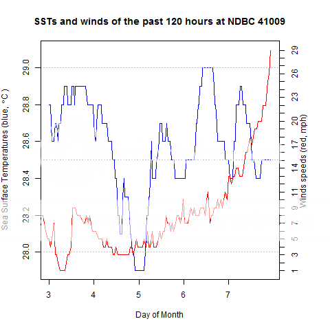
The figure of sea surface temperatures and winds didn't go as planned.  NBDC Buoy 41009 was lost to Hurricane Matthew at 0830Z today.  The winds came in quickly and knocked the device right off its moorings.

The damage was minimal, but there was a large branch down in my yard, about 6 inches in diameter


I'm looking for others to share their stories of any interesting pre-storm preparations or post-storm findings!  If I get enough, I could make another blog post for all of it!

Hurricane Matthew Blog - Part 3

As daylight breaks, it appears that damage in the Melbourne area has been kept to a minimum.  We'll see as the day goes on and the storm lifts out.

Winds have grown in the last few hours, and there are widespread power outages.  Keep safe!

Hurricane Matthew Blog - Part 2

Sorry for not posting sooner... figures didn't like to work.
Check out the temperature drop over the last few hours... and it should plunge over the next few, which I hope will be around my next update.

Outer eyewall now affecting Cape Canaveral.  Remember to stay away/inside until authorities say is safe to come back/out.

Thursday, October 6, 2016

Hurricane Matthew Blog - Part 1

If you're watching the Weather Channel right now, you may have heard Carl Parker essentially guarantee the death of any people who don't leave the barrier islands of Florida's east coast.  If you've read the NWS Melbourne updates, you may have read the line saying that remaining may result in "injury, death, or immense human suffering."

Take it seriously.

It's too late to leave, now, unless you're going to somewhere inland, like NW or SW Palm Bay.

Forecast is improved due to eyewall replacement.

NDBC buoy 41009 should nicely capture the hurricane passage... I'll try to work out a solution to include the charts I want to share throughout the passage of the storm.

More details later.  There is method to my madness.  Credits go to Mitch Roffer for unintentionally giving me this idea!

FORECAST POSITIONS AND MAX WINDS

INIT  06/2100Z 26.2N  78.6W  120 KT 140 MPH
 12H  07/0600Z 27.6N  79.9W  115 KT 130 MPH
 24H  07/1800Z 29.6N  81.0W  110 KT 125 MPH
 36H  08/0600Z 31.2N  81.0W   95 KT 110 MPH
 48H  08/1800Z 32.1N  80.0W   80 KT  90 MPH
 72H  09/1800Z 31.5N  76.5W   60 KT  70 MPH
 96H  10/1800Z 29.0N  76.5W   50 KT  60 MPH
120H  11/1800Z 27.5N  77.5W   40 KT  45 MPH